

Soil, Water & Land Health · Soil Fundamentals
Understanding the Soils on Your Property
A soil map will not tell you everything about a property, but it can explain a surprising amount: where water lingers, why one pasture outperforms another, where roads fail, and why some improvement projects work better in one place than another.
A landowner can spend years looking across the same property without ever seeing the boundaries that matter most beneath the surface. One pasture grows grass well through a dry summer while another fades quickly. A road stays firm for half a mile and then turns soft after every rain. One pond holds water reliably while another is always suspect. Trees flourish along one slope and struggle on the next.
Those differences are often rooted, quite literally, in the soil.
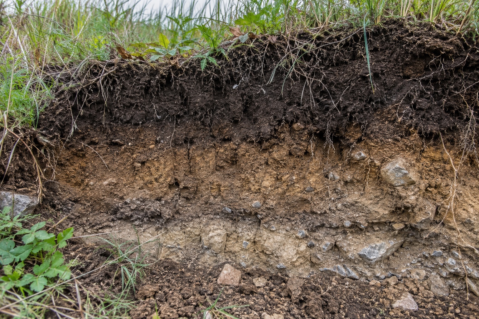
Most properties contain more variation than they first appear to. Soil depth, texture, drainage, slope, underlying rock, and organic matter can change over relatively short distances. USDA soil surveys exist precisely because those differences affect how land can be used. Understanding those differences does not require becoming a soil scientist. It does require knowing which characteristics matter and how to use the information without asking more of it than it can provide.
Start with the soil map, then go outside
For most U.S. properties, the logical starting point is the USDA Natural Resources Conservation Service Web Soil Survey. It is the current official source for National Cooperative Soil Survey information and allows a user to define an area of interest—such as a property—and view mapped soil units and their associated characteristics and interpretations.
At first glance, the resulting map can look more complicated than useful. A property may be divided into several named soil units, each with percentages, slopes, component soils, and a long list of technical attributes. Resist the urge to absorb all of it.
The first useful question is simply: Where does the soil change?
If an 800-acre ranch contains five major soil units, those boundaries deserve attention. Compare them to aerial imagery, vegetation, slopes, wet areas, road problems and the way the property has historically been used. The lines on the soil map will not match the ground perfectly, but they often explain patterns that were already visible without being understood.
Web Soil Survey is a planning tool, not a substitute for onsite investigation. A map can tell you where to look more carefully; it should not be treated as proof of what exists at a particular shovel-sized point.
Texture tells you a great deal about how a site behaves
One of the most useful soil characteristics to understand is texture: the relative amount of sand, silt and clay.
A sandy soil generally allows water to move through it more readily and often dries more quickly. Clay-rich soils tend to hold more water but may drain slowly, become sticky when wet, and shrink or harden when dry. Loams occupy a middle ground, though the exact behavior depends on the particular mixture and structure of the soil.
That basic distinction affects much more than gardening.
It helps explain why a road base performs differently across a property, why certain areas stay wet, why some sites are more susceptible to compaction, and why vegetation can change sharply along a seemingly subtle boundary. It also matters when considering ponds, septic systems, building sites, erosion control and revegetation.
Texture alone is not enough to predict all of those outcomes, but it is often the first clue.
A landowner does not need to memorize a soil-texture triangle to make use of the concept. What matters is recognizing that a coarse, loose soil and a dense clay soil will not respond the same way to water, traffic or disturbance.
Depth may matter more than the surface suggests
A property can look fertile from above while having very little usable soil beneath the vegetation.
Depth to restrictive layers—such as bedrock, dense subsoil or other limiting material—can affect rooting depth, available water, plant productivity, excavation and construction. Shallow soils on rocky uplands often support a very different plant community from deeper soils only a short distance away.
This matters when landowners try to force one management objective across an entire property.
A shallow, rocky site may never produce forage like a deep bottomland soil, regardless of how much effort is spent improving it. Conversely, that shallow site may have excellent value for native plants, wildlife cover or a plant community specifically adapted to those conditions.
Knowing the limitation early can prevent spending money trying to make one piece of land behave like another.
Drainage deserves particular attention
Some soil characteristics become most obvious only after rain.
Poorly drained or seasonally wet soils can affect roads, buildings, grazing patterns, root health, septic suitability and equipment access. Other soils shed water rapidly and may contribute to runoff or erosion problems on slopes.
Web Soil Survey includes information related to drainage, hydrologic soil groups, runoff, flooding and other water-related characteristics. That information becomes much more valuable when compared with what you see on the ground.
If a mapped soil is described as poorly drained and you already know that pasture becomes difficult to cross after a modest rain, the map is confirming a condition you should probably design around rather than continually fight.
The same logic applies in reverse. If a map suggests a limitation that is not obvious, it gives you a reason to inspect the site under the conditions when that limitation is most likely to appear.
Soil health is different from soil type
This distinction is easy to miss.
Soil type describes characteristics that are largely inherent to the site: texture, mineral composition, depth, landscape position and other relatively persistent features.
Soil health describes how well the soil is functioning and can change with management.
NRCS evaluates soil health using physical, chemical and biological indicators rather than relying on a single measure. Examples include organic matter, infiltration, soil structure, bulk density, water-holding capacity, pH, nutrient status and biological activity.
That means two areas with the same mapped soil can perform differently after years of different treatment.
Repeated heavy traffic can compact one. Continuous overgrazing can reduce protective cover and organic inputs. Good grazing management, plant diversity and reduced disturbance can improve structure and infiltration over time.
A soil map tells you what you are starting with. Soil condition tells you something about what has happened since.
A laboratory soil test answers a different question
Landowners often use “soil survey” and “soil test” interchangeably, but they serve different purposes.
A soil survey helps describe and map the soil itself: its physical properties, landscape position, limitations and expected behavior.
A laboratory soil test generally evaluates conditions such as pH and plant-available nutrients for management decisions. It is particularly useful when deciding whether fertilizer or soil amendments are warranted.
One should not substitute for the other.
A fertility report showing low phosphorus does not explain whether a site is poorly drained or shallow to bedrock. Likewise, a mapped soil description does not tell you whether the current pasture needs lime or fertilizer.
On agricultural ground, improved pasture, food plots, hay fields or other intensively managed areas, both may be useful.
What deserves attention on a soil report
A full soil report can contain far more information than most landowners need for an initial review. The following characteristics are a reasonable first pass.
| Soil characteristic | Why it matters on the property |
|---|---|
| Texture | Influences drainage, water retention, trafficability and plant growth |
| Depth | Affects rooting, available water, excavation and some construction uses |
| Slope | Influences runoff, erosion risk, equipment use and road design |
| Drainage | Helps explain wet areas, access problems and some vegetation patterns |
| Flooding or ponding | Important for structures, access, agriculture and infrastructure |
| Available water capacity | Helps indicate how much water the soil can store for plants |
| Erosion susceptibility | Useful when planning grazing, roads, clearing or revegetation |
| Interpretations for specific uses | Can identify potential limitations for roads, septic systems, ponds and other projects |
The value of this table is not that every characteristic deserves equal attention. It is that each gives you another way to ask whether a proposed use fits the site.
Soil limitations are not always problems
The word limitation can sound more negative than it should.
A soil poorly suited to one purpose may be entirely appropriate for another. Shallow rocky soils may be poor choices for cultivation but support valuable native habitat. Frequently wet soils can complicate road construction while providing productive riparian or wetland vegetation. Sandy soils may require different fertility or water management but support plant communities well adapted to them.
Good land management usually works with those differences rather than trying to erase them.
That becomes especially important on larger properties, where forcing the same treatment across every acre can waste money and reduce ecological diversity at the same time.
Use the soil information when a real decision is being made
The most useful time to study soil is before committing to a project.
If you are considering a new ranch road, look at the soils along the proposed alignment. If you are evaluating a pond site, investigate the soils in the basin and embankment area rather than assuming the mapped description is sufficient. If a pasture consistently underperforms, compare its soil and landscape position with better-performing ground before deciding that fertilizer is the answer.
For major earthwork, structural work, dams, septic systems or other uses where failure would be expensive, a generalized soil map should lead to onsite investigation rather than replace it.
The point is not to turn soil information into another layer of complexity. It is to avoid discovering an important site limitation after the work has already begun.
Learn the differences that matter on your own property
You do not need to know the formal name of every soil series to manage land well. What matters is recognizing where one part of the property behaves differently from another and understanding enough about those differences to make better decisions.
Start with the map. Compare it with the terrain and vegetation. Look at how each area responds to rain. Dig into the ground where something does not make sense. Use laboratory testing when fertility is the question, and bring in more specialized investigation when the stakes justify it.
Over time, the soil map stops looking like a collection of polygons and begins to look more like a description of why the property behaves the way it does.
That is when it becomes useful.
References
- USDA Natural Resources Conservation Service — Web Soil Survey
Official soil survey information and land-use interpretations for properties throughout the United States.
- USDA Natural Resources Conservation Service — Soil Survey
Overview of how soil surveys describe soil characteristics, limitations and potential uses.
- USDA Natural Resources Conservation Service — Soil Health Assessment
Guidance on physical, chemical and biological indicators used to evaluate soil function and condition.
- USDA Natural Resources Conservation Service — Soil Health
Information on the relationship between soil function, water retention, runoff, erosion and land management.
- USDA Natural Resources Conservation Service — Role of Organic Matter
Technical discussion of organic matter, soil structure, infiltration and water-holding capacity.